

Photographs from on high
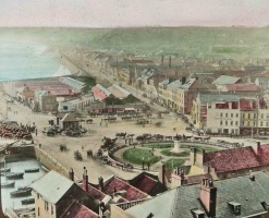
This page contains the largest selection of photographs of St Helier's Weighbridge area, all taken from very similar viewpoints, looking down on the area from Fort Regent. Although all are included in our full gallery of Weighbridge photographs, we have decided to extract only those taken from the Fort, to provide a fascinating chronology of how the area has developed over the years.
Although the area is still called the Weighbridge, and probably always will be, the two structures which gave it this name no longer exist. The first public weighbridge was built on the far right of the majority of the photographs below, in front of the Southampton Hotel. When land was reclaimed from the top of the Old Harbour for the first time, in the late 1880s, to allow for the eventual construction of the circular gardens, with a statue of Queen Victoria in the centre, this weighbridge was demolished, and replaced with a larger structure close to the top of the New North Quay. That, in turn, was demolished in the late 20th century, and the gardens and the statue have also disappeared.
Dating photographs
Ascribing an accurate year to photographs taken many decades, and sometimes more than one and a half centuries, ago can be extremely difficult. The first clue is often a date written on the back, or in a caption to an online image. But such dates can be extremely unreliable. In the course of researching this page we have identified several errors in the dates shown in our full gallery of Weighbridge photographs. Those dates came from somewhere, but it is often only detailed research that can allow them to be corrected.
Ironically all the information needed to research this new chronology was already in our website, on one page or another, and we started by compiling a basic timeline of developments in this area, all of which was reclaimed from the sea, some sections more recently than others, before any buildings could be erected.
The best guide to dating some of the earliest photographs of this area is the progress of the development of what is known as the 'Island Site' which forms the background to many of the pictures on this page. It is the area bounded by the Weighbridge itself, the start of the Esplanade and the top of the Albert Harbour. It is clearly shown in this picture, as it appeared in 1879. A number of elements enable us to settle on that date:
- Working forwards:
- The new weighbridge in the foreground was built in 1877
- The printed back of the photograph, taken by Ernest Baudoux, refers to the photographer's successes in 1878 Paris exhibitions
- And working backwards:
- The new abattoir, which was built at the far end of the 'Island Site' in 1888, has yet to be started
- The design of the photograph back is known to have been used by Baudoux up to 1885, when he was joined in business by his son before retiring two years later
- Work is under way to improve the frontage of the Jersey Railway terminus in the right foreground. The sign Jersey Railway Refreshment Room can be seen to be in a state of disrepair and the end gable of the terminus roof is open, but work has started to fill it in. In 1880 the work was complete, the refreshment room sign had been refurbished and a larger Jersey Railway sign had been placed on the new wall above

A knowledge of dates when numerous other changes were made to the scene enables many other photographs to be accurately dated. Some of the key changes were as follows [1]:
- 1863 - Harbour Office built on south-east corner of what would become the 'Island Site'
- 1867-68 - Island site fully laid out and buildings constructed
- 1869 - Shortening of northern end of these buildings to allow construction of the railway to open
- 1870 - Railway opens
- 1877 - New public weighbridge constructed
- 1880 - Changes to front of railway terminus building
- 1884 - Top of old harbour filled in
- 1888 - Circular garden constructed with large flagpole in centre
- 1890 - Unveiling of Queen Victoria statue to replace flagpole [2]
- 1893 - Parabolic single-span roof of railway terminus replaced with two spans of triangular design
- 1895 - Photographs of the Weighbridge area start to appear as postcards [3]
- 1901 - New terminal building replaces old 'refreshment rooms' in what was originally the old cattle market building
- 1972 - Statue moved to new position in front of former railway terminus, not the Tourism Office
- 1976 - Statue moved again, this time away from the Weighbridge to the Triangle Park at West Park

An exception to the general rule for this page that photographs were taken looking down from Fort Regent. This is the earliest known photograph of some of the familiar Weighbridge buildings, taken from across the Harbour. It is believed to date from about 1850, but cannot have been taken any later than 1863 because the building which was the Harbour Office for more than a century, has yet to be built

This was said to be 1865 but it has to be earlier because, although it is a very poor quality image, it is possible to see that there is no Harbour Office building

The first weighbridge, the construction of which was ordered by the States in 1825, was situated next to the Southampton Hotel. This picture dates to the mid-1870s, because in 1877 the new, larger weighbridge, further south of the Southampton Hotel, started to be used. It is not known who took this photograph, but it is attributed to both Edwin Dale and Ernest Baudoux by the photographic archive of La Société Jersiaise. It cannot have been Edwin Dale, because he was not born until 1882!

1885

1890

1893

This picture dates to between 1888 and early 1890, because the circular gardens have been laid out, but the Statue of Queen Victoria, which was unveiled in the centre of 3 September 1890 is not yet in place

1890s

1890

1895

1897

1902

1905

In 1928 a further substantial section of the top of the harbour was filled in to provide more space for harbour activities and for car parking.


Notes and references
- ↑ This list will be expanded as more dates are researched
- ↑ An analysis of the degree of growth shown by the shrubs planted when the garden was opened can allow pictures taken from 1890 to the end of the century to be placed in sequence, and exact years determined by other features
- ↑ As with any postcard, the photograph was not necessarily taken in the year the card was posted, or even the year it was published